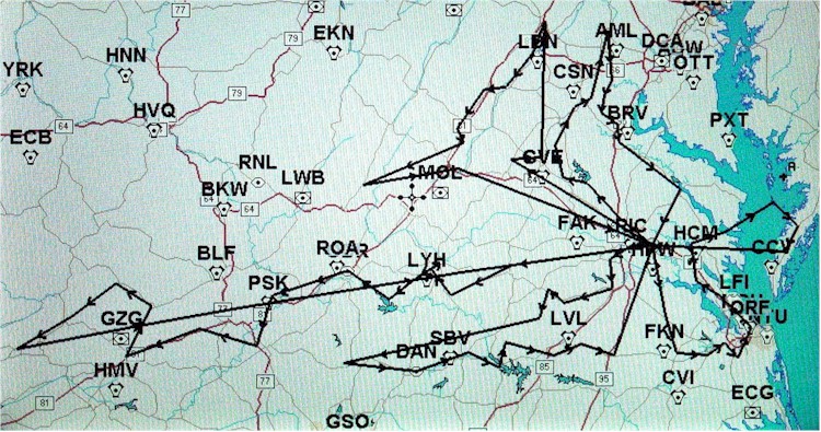
 As another GPS flight planning exercise I proposed a series of missions to fly to each of
the 67 Virginia airports in the Virginia
Aviation Ambassador Program. This plan was developed on the Avmap EKP-IV using the map display and internal
database. The sequence was determined by starting from home field (W96) and
routing to each next nearest unvisited field. After a resonable number of hops, I
inserted a return to base leg, resulting in 5 sorties of reasonable length/number of
stops. Where this procedure missed any fields, they were manually inserted into the
nearest leg. The table below shows the sequence. Airnav links are provided for
each facility. The total distance is 2000 nautical miles, with the single longest
leg under 300 nautical miles (well within the normal range envelope of the Cheetah).
DCA and IAD airports were not included in this plan.
As another GPS flight planning exercise I proposed a series of missions to fly to each of
the 67 Virginia airports in the Virginia
Aviation Ambassador Program. This plan was developed on the Avmap EKP-IV using the map display and internal
database. The sequence was determined by starting from home field (W96) and
routing to each next nearest unvisited field. After a resonable number of hops, I
inserted a return to base leg, resulting in 5 sorties of reasonable length/number of
stops. Where this procedure missed any fields, they were manually inserted into the
nearest leg. The table below shows the sequence. Airnav links are provided for
each facility. The total distance is 2000 nautical miles, with the single longest
leg under 300 nautical miles (well within the normal range envelope of the Cheetah).
DCA and IAD airports were not included in this plan.
|
|
|
|
Flight Plan |
|
|
| Region |
Controlled |
Airport |
Identifier |
Sortie |
Flight plan sequence |
Distance
(leg, nm) |
Totals |
| 4 |
No |
New Kent County |
W96 |
1 |
1 |
|
|
| 1 |
Yes |
Richmond International |
RIC |
1 |
2 |
9.2 |
|
| 6 |
No |
Chesterfield County |
FCI |
1 |
3 |
11.5 |
|
| 6 |
No |
Dinwiddie County |
PTB |
1 |
4 |
13.4 |
|
| 6 |
No |
Blackstone |
BKT |
1 |
5 |
22.3 |
|
| 6 |
No |
Crewe Municipal |
W81 |
1 |
6 |
9.5 |
|
| 6 |
No |
Lunenburg County |
W31 |
1 |
7 |
13.9 |
|
| 2 |
No |
Blue Ridge |
MTV |
1 |
8 |
90.3 |
|
| 5 |
No |
Danville Regional |
DAN |
1 |
9 |
33.1 |
|
| 5 |
No |
William Tuck (South Boston) |
W78 |
1 |
10 |
25.0 |
|
| 6 |
No |
Marks Municipal |
W63 |
1 |
11 |
15.5 |
|
| 5 |
No |
Chase City |
CXE |
1 |
12 |
11.9 |
|
| 6 |
No |
Mecklenburg/Brunswick |
AVC |
1 |
13 |
22.4 |
|
| 6 |
No |
Lawrenceville/Brunswick |
LVL |
1 |
14 |
13.5 |
|
| 6 |
No |
Emporia Municipal |
EMV |
1 |
15 |
15.9 |
|
|
|
Return to base |
W96 |
|
|
51.9 |
359.2 |
| 6 |
No |
Wakefield |
AKQ |
2 |
16 |
31.5 |
|
| 7 |
No |
Franklin Municipal |
FKN |
2 |
17 |
20.0 |
|
| 7 |
No |
Suffolk Municipal |
SFQ |
2 |
18 |
14.6 |
|
| 7 |
No |
Hampton Roads |
PVG |
2 |
19 |
9.4 |
|
| 7 |
No |
Chesapeake Municipal |
CPK |
2 |
20 |
9.2 |
|
| 7 |
Yes |
Norfolk International |
ORF |
2 |
21 |
14.9 |
|
| 7 |
Yes |
Newport News-Williamsburg International |
PHF |
2 |
22 |
20.0 |
|
| 7 |
No |
Williamsburg-Jamestown |
JGG |
2 |
23 |
12.5 |
|
| 4 |
No |
Middle Peninsula Regional |
FYJ |
2 |
24 |
17.1 |
|
| 4 |
No |
Hummel Field |
W75 |
2 |
25 |
15.9 |
|
| 7 |
No |
Tangier Island |
TGI |
2 |
26 |
25.2 |
|
| 7 |
No |
Accomack County |
MFV |
2 |
27 |
15.5 |
|
| 7 |
No |
Campbell (Was Kellam Field W08) |
9VG |
2 |
28 |
12.6 |
|
|
|
Return to base |
W96 |
|
|
59.5 |
277.8 |
| 4 |
No |
Hanover County |
OFP |
3 |
29 |
19.3 |
|
| 4 |
No |
Lake Anna |
7W4 |
3 |
30 |
21.3 |
|
| 4 |
No |
Louisa County |
LKU |
3 |
31 |
11.0 |
|
| 3 |
No |
Orange |
OMH |
3 |
32 |
14.7 |
|
| 3 |
No |
Culpeper County |
CJR |
3 |
33 |
19.0 |
|
| 3 |
No |
Warrenton-Fauquier |
W66 |
3 |
34 |
7.8 |
|
| 3 |
No |
Leesburg Municipal |
JYO |
3 |
35 |
30.4 |
|
| 3 |
No |
Manassas Regional |
HEF |
3 |
36 |
21.5 |
|
| 2 |
No |
Whitman Strip |
0V5 |
3 |
37 |
7.7 |
|
| 3 |
No |
Hartwood |
8W8 |
3 |
38 |
7.4 |
|
| 3 |
No |
Stafford |
RMN |
3 |
39 |
9.0 |
|
| 4 |
No |
Shannon |
EZF |
3 |
40 |
7.9 |
|
| 4 |
No |
Tappahannock Municipal |
W79 |
3 |
41 |
34.1 |
|
|
|
Return to base |
W96 |
|
|
28.1 |
239.0 |
| 6 |
No |
Farmville |
FVX |
4 |
42 |
63.2 |
|
| 5 |
No |
Brookneal/Campbell County |
0V4 |
4 |
43 |
30.5 |
|
| 5 |
Yes |
Lynchburg Regional |
LYH |
4 |
44 |
14.3 |
|
| 5 |
No |
Falwell |
W24 |
4 |
45 |
4.8 |
|
| 5 |
No |
New London |
W90 |
4 |
46 |
12.0 |
|
| 2 |
No |
Smith Mountain Lake |
W91 |
4 |
47 |
15.8 |
|
| 2 |
Yes |
Roanoke Regional Airport |
ROA |
4 |
48 |
22.5 |
|
| 1 |
No |
Virginia Tech/Montgomery |
BCB |
4 |
49 |
21.8 |
|
| 1 |
No |
New River Valley |
PSK |
4 |
50 |
13.6 |
|
| 1 |
No |
Twin County |
HLX |
4 |
51 |
23.3 |
|
| 1 |
No |
Mountain Empire |
MKJ |
4 |
52 |
26.5 |
|
| 1 |
No |
Virginia Highlands |
VJI |
4 |
53 |
35.2 |
|
| 1 |
No |
Tazewell County |
6V3 |
4 |
54 |
25.3 |
|
| 1 |
No |
Grundy Municipal |
GDY |
4 |
55 |
18.6 |
|
| 1 |
No |
Lonesome Pine |
LNP |
4 |
56 |
24.3 |
|
| 1 |
No |
Lee (Pennington Gap) (was PTG) |
VG54 |
4 |
57 |
28.3 |
|
|
|
Return to base |
W96 |
|
|
286.6 |
666.6 |
| 5 |
Yes |
Charlottesville-Albemarle |
CHO |
5 |
58 |
73.6 |
|
| 3 |
No |
Gordonsville |
GVE |
5 |
59 |
13.6 |
|
| 2 |
No |
Winchester Regional |
OKV |
5 |
60 |
59.3 |
|
| 3 |
No |
Front Royal-Warren County |
FRR |
5 |
61 |
14.5 |
|
| 3 |
No |
Luray Caverns |
W45 |
5 |
62 |
19.0 |
|
| 3 |
No |
New Market |
8W2 |
5 |
63 |
9.7 |
|
| 2 |
No |
Bridgewater Air Park |
VBW |
5 |
64 |
21.0 |
|
| 2 |
Yes |
Shenandoah Valley Regional |
SHD |
5 |
65 |
6.9 |
|
| 2 |
No |
Ingalls Field |
HSP |
5 |
66 |
48.1 |
|
| 2 |
No |
Eagles Nest (was W13) |
21VA |
5 |
67 |
42.8 |
|
|
|
Return to base |
W96 |
|
|
92.9 |
401.4 |
|
|
Totals |
|
|
|
637.0 |
1944.0 |
|
|
|
|
|
|
|
|
| 2 |
Yes |
Ronald Reagan National Airport |
DCA |
|
|
|
|
| 2 |
Yes |
Dulles International Airport |
IAD |
|
|
|
|
|
|
 Virginia Aviation Ambassador from W96